
The glaciers of the Himalayas are continuously shrinking. In the last 3 decades, a large part of the ice has disappeared and now its effect is not limited to the mountains only. The changes taking place in the glaciers will also affect the availability of water in the future and the risk of disaster in the Himalayan areas.
.
A report by the International Center for Integrated Mountain Development (ICIMOD), based on data from 1990 to 2020, has revealed that the area of glaciers in the entire Hindu Kush Himalaya decreased by 11.6%. The special thing is that after 2010, the pace of shrinkage of glaciers has increased further. The area of glaciers in the upper Ganga region associated with Uttarakhand has also decreased by 18.6% in three decades.
Although the number of glaciers has increased in many areas, the total area covered by snow has decreased. After all, why is the size of glaciers decreasing despite the increase in number, at which heights the snow melted the most and how worrying is the picture of the glaciers of Uttarakhand? Read the full report to know.
Through this map in the report, it has been told what is the condition of the glaciers where.
The pace of snow melting has increased after 2010
The most worrying thing in the report is from the last decade. There was a slight 0.3% increase in the number of glaciers between 1990 and 2000, but this did not mean glaciers were expanding. The number increased due to the breaking of large glaciers into smaller glaciers. On the other hand, the area continued to decrease.
Between 2000 and 2010, the number of glaciers decreased by 0.8% and their area decreased by about 4%. During 2010 to 2020, the decline in numbers increased to 1.7% and the area decreased to about 4.9%. The number of glaciers decreased by 2.2% and area by 11.6% in the entire 30 years.
Even if the numbers seem to be increasing, there is no reason to be happy
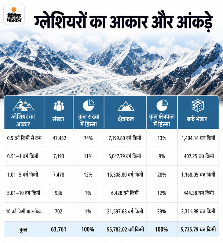
A very interesting conclusion of this report is that the number of small glaciers has increased in many places, but their total area is decreasing. The reason for this is the splitting and shrinking of glaciers. In 2020, the number of glaciers smaller than 0.5 sq km was 47,452, i.e. 74% of the total glaciers. But despite being so large, they hold only 13% of the total glacier area and 24% of the estimated ice reserves.
In contrast, glaciers 10 square km or larger number only 702, or about 1% of the total number, but they occupy 39% of total glacier area and about 40% of ice reserves.
Maximum damage at altitude of 5,000 to 5,500 meters
Glaciers are not melting at the same rate at every altitude. According to the report, the largest area loss between 1990 and 2020 occurred at an altitude of 5,000 to 5,500 meters. The surrounding areas at 4,500–5,000 m and 5,500–6,000 m altitude also saw their area reduced by about 15–15%. Glaciers below 5,500 meters in particular were found to be more sensitive to changes in temperature and precipitation.
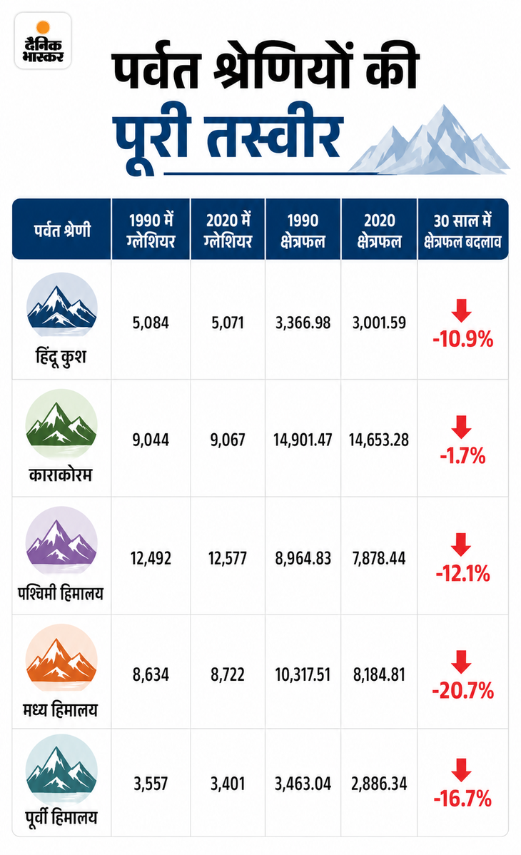
Glacier area decreased by 20.7% in the Central Himalaya, 16.7% in the Eastern Himalaya and 12.1% in the Western Himalaya. The area in Hindu Kush also decreased by 10.9%. Whereas Karakoram appeared relatively stable. Here only 1.7% reduction in glacier area was recorded.
Big loss of ice in Ganga-Brahmaputra
If we look at the rivers, the picture becomes more important. Glacier area in the Ganga river basin decreased from 9,500.52 sq km in 1990 to 7,518.52 sq km in 2020. That means a decrease of 20.9%. The area in the Brahmaputra river basin decreased from 11,241.63 to 9,450.32 km, a decrease of 15.9%.
The most severe decline was in the Salween River basin, where glacier area decreased by 32.7%. A decrease of 23.1% was recorded in the Yangtse and 22.2% in the Yellow River.
According to 2020 data, the Western Himalayas have the highest number of glaciers, 12,575. This accounts for 19.73% of the glaciers of the entire Hindu Kush Himalaya. But Karakoram is at the forefront in terms of area. There are 9,067 glaciers and their total area is 14,653.28 km², which is 26.27% of the glacier area of the entire region. After this, the share of Western Himalaya is 14.12% and Central Himalaya is 14.67%.
Danger looming on the glaciers of Uttarakhand
Himalayan glaciers, considered the lifeline for the rivers of Uttarakhand, are shrinking rapidly. Between 1990 and 2020, the total area of glaciers in the upper Ganga region associated with Uttarakhand decreased by 18.6 percent. The surprising thing is that the number of glaciers has increased during this period.
This means that glaciers are not growing, rather big glaciers are breaking and dividing into smaller parts. The study has assessed the changes in glaciers over three decades on the basis of satellite images.
1,448 glaciers in part of Uttarakhand
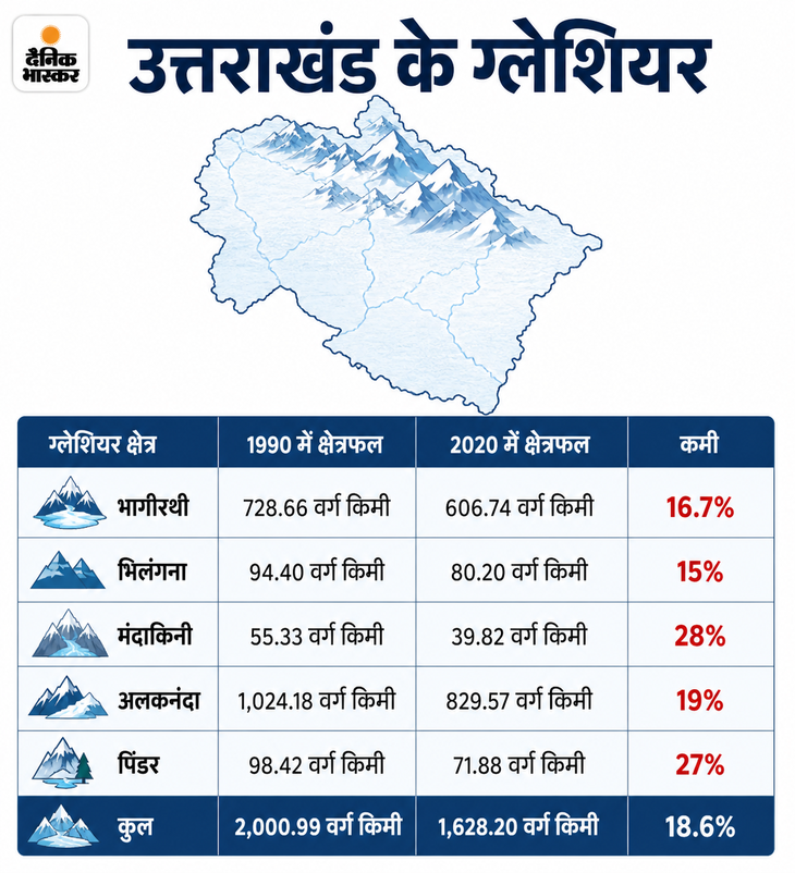
The report includes Bhagirathi, Bhilangana, Mandakini, Alaknanda and Pindar areas belonging to Uttarakhand under the Upper Ganga region. A total of 1,448 glaciers were recorded in these areas in the year 2020. Their total area was 1,628.20 square kilometers. In 1990, there were 1,357 glaciers and their area was 2,000.99 square kilometers.
That means in 30 years the number of glaciers increased by 6.7 percent, but the snow covered area decreased by 372.79 square kilometers.
The report has described Gangotri Glacier, the identity of Uttarakhand, as the largest glacier of the Ganga river basin. It is located in the Bhagirathi sub-basin and its area was recorded as 125.8 square kilometers in the year 2020. It is the only glacier larger than 100 square kilometers in the Ganga basin.
The glaciers in the upper Ganga region associated with Uttarakhand extend from a height of about 3,816 to 7,454 meters. On one hand, the shrinking of glaciers can affect water availability in the future, while on the other hand, the risk of incidents like increase in glacier lakes, sudden lake bursts and Himalayan disasters also becomes important.
The pace of glacier melting increased rapidly in the last decade
The report also gives important indications regarding the speed of shrinkage of glaciers. The glacier area in the Ganga river basin decreased by about 21 percent between 1990 and 2020. Whereas in the decade from 2010 to 2020, the pace of area decline was higher as compared to earlier decades.
The total glacier area in the upper Ganga region of Uttarakhand also decreased by 5.6 percent during 2010 to 2020. In comparison, a decrease of 5.8 percent was recorded between 2000 to 2010 and 8.6 percent between 1990 to 2000.
Highest glacier between 5,000 and 6,000 meters
More than 81 percent of the glaciers in the Ganga River basin lie between 5,000 and 6,500 meters altitude. More than 64 percent of these areas are concentrated between 5,000 and 6,000 meters altitude. According to the study, about 20 percent reduction has been recorded in the glacier area between 5,000 and 5,500 meters.
There has been a decrease of about 21 percent between 4,500 to 5,000 meters and about 15 percent between 5,500 to 6,000 meters. ——————–
Read this news also…..
Complete record of Himalayan monsoon found in Uttarakhand: Drought occurred 4,200 years ago; Rain changed the picture of forests 2,600 years ago
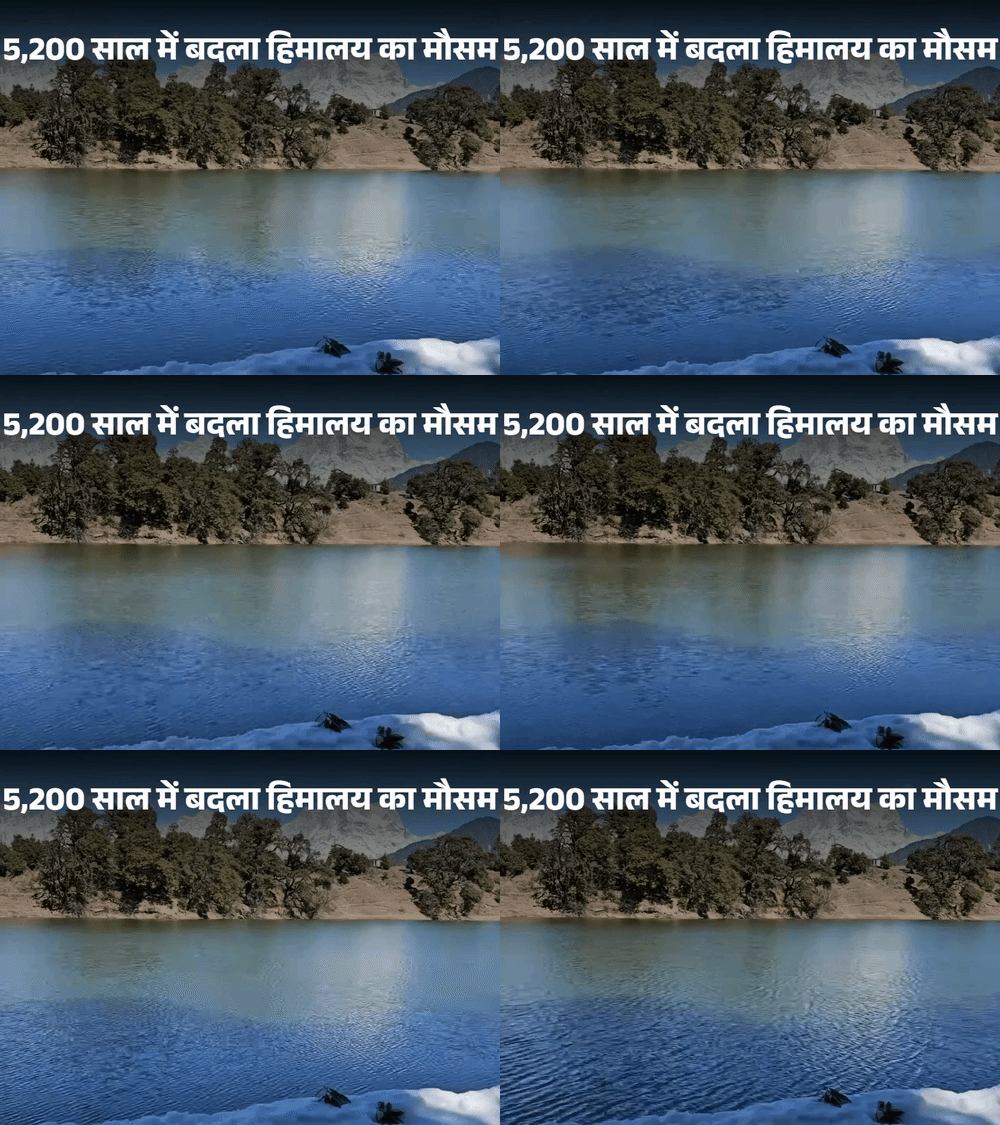
Deoria Tal present in the Garhwal Himalayas of Uttarakhand is not just a beautiful lake. Records of the weather of the last 5,200 years have been found hidden in the layers of soil deposited at its foothills. By studying the pollen of trees and plants found in these layers, scientists found out when the monsoon weakened in the Himalayas, when there was drought for a long time and when the rainfall increased so much that the picture of the forests changed. (Read full news)
Source link
[ad_3]

