
Taking concrete steps against terror, the Indian Army has started the exercise of Operation Sindoor, since then social media has been covered with all the claims. After the ceasefire, even though the war -like conditions between the two countries have stopped, the tension on the border is still intact, while it is also clarified during the press briefing by the army that “Operation Sindoor” has not ended yet.
Meanwhile, there are many such claims on social media that the Indian Army attacked a nuclear facility in Sargodha, Pakistan during ‘Operation Sindoor’. Although Mushaf Airbase in Sargodha was being called a target of India’s missile attack, Air Marshal AK Bharti denied that India targeted a nuclear facility in Grocery Hills on Monday.
Air Marshal Bharti said, “We did not attack the Kirana Hills; I did not mention it in my briefing yesterday.” Both these places are barely 7 kilometers away, and in the viral video on social media, thick smoke is seen rising from the base of bumpy mountain peaks. Due to the absence of high-government satellite imagery, it is difficult to clarify that in the grocery hills, if there was a nuclear property, were they targeted?
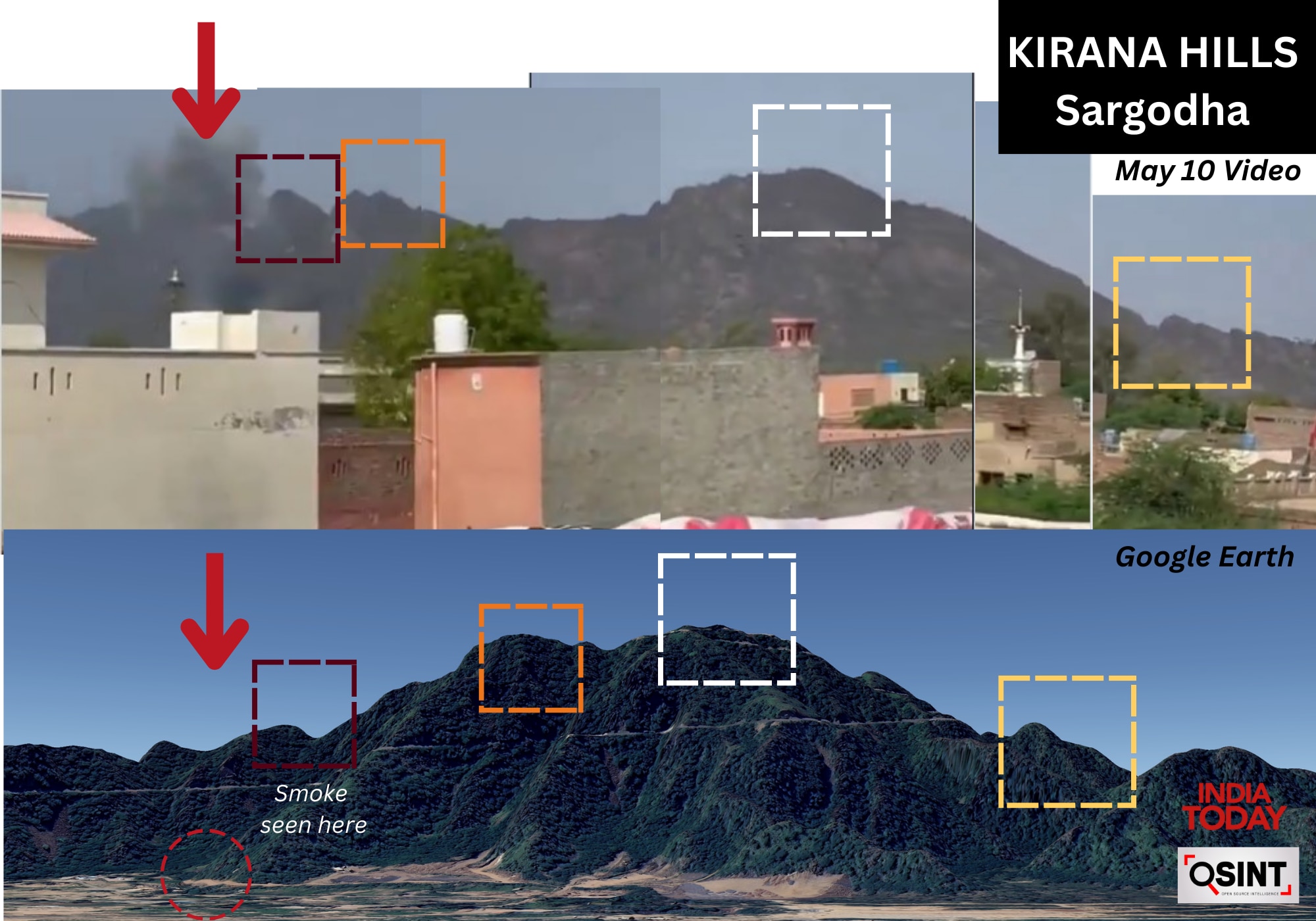
The footage posted on the day of the attack on social media showed smoke from the surrounding peaks. The source of smoke can be kept near the surrounding peaks based on the geolocation made by India Today’s open-source intelligence (OSINT) team. Interestingly, Air Marshal Bharti also denied information about the existence of nuclear property in Kirana Hills.
In a video viral viral on social media, a person claims that the Indian Army carried out missile attacks on Grocery Hills.
When was the grocery hills identified
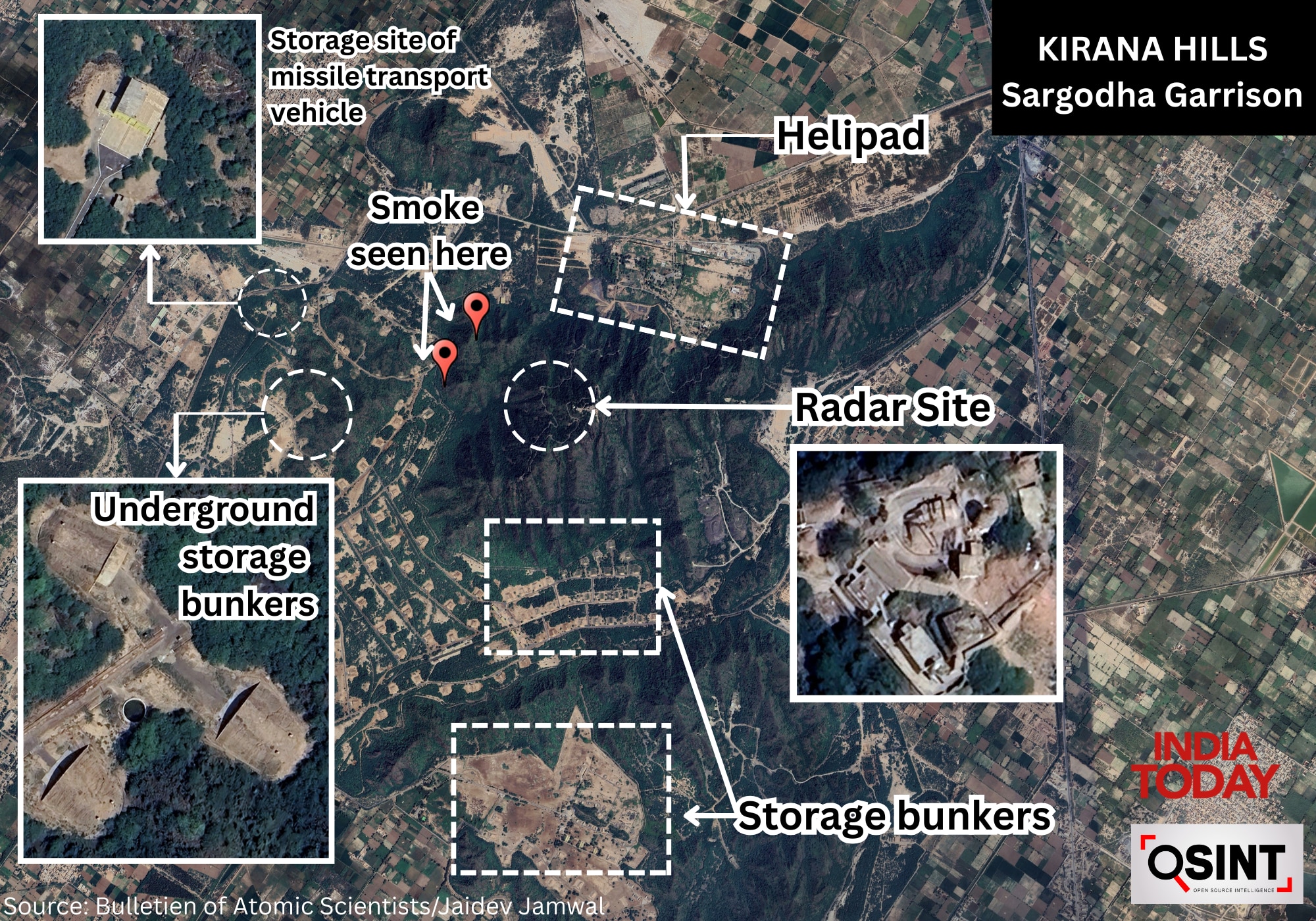
The Kirana Hills and the surrounding areas were identified in a 2023 report as a “subcutical nuclear test site”, published by an NGO called Bulletin of the Atomic Scientists. The report said that this site consists of probably ammunition storage area, TEL (Transporter Eractor Launcher) Garage, and at least ten underground storage facilities. The conclusion was part of the nuclear notebook, which was written by scientists from the Federation of American Scientists for a bulletin, an international think tank on global security.
Geolocation of social media footage shows that the source of smoke can be less than one kilometer away from the missile transport vehicle store, which has been mentioned in the report. The affected area is about 550 meters from the radar on the top of a hill. Geolocation of the video, which is particularly based on the hilltop structure, matches a large extent from the terrain visible on Google Earth. A nearby mosque seen in the footage confirms the location when compared with high-resolution satellite imagery.
What is in Sargodha?
Sargodha Garyson is a large campus, located around and inside the Grocery Hills, which was allegedly used by Pakistan between 1983 and 1990 to pursue its nuclear program. In the exact northwest of a potential traditional ammunition storage area, ten scattered potential TEL garages appear, as well as two extra garages that can occur for maintenance.
Senior researcher Matt Corda mentioned in his report that unlike other TEL facilities across the country, this TEL region lacks standard layout and perimeter. The traditional ammunition is an underground storage facility to the east of the site, which is built in the slope of the mountain.
Hans M. Kristensen and his team stated in their report that “at least 10 underground facility entrees appear through the Commercial Satellite Imagery, as well as the facility for weapons and missile handling.” The satellite image of the grocery complex was not present after the attack, due to which further enllisse could not be possible.
Apart from Sargodha, those airports in Pakistan were also attacked, where Mirage III and Mirage v fighter jets are posted, which are believed to play the role of nuclear delivery role. These include two major hideouts. Rafiki near Masroor and Shorkot.
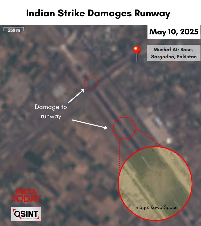
Disadvantage on the runway of Mushaf Airport
Although there is no official confirmation about Masroor, the Indian Army Colonel Sophia Qureshi confirmed that India attacked the Rafiki airport. A pit of this hideout is seen in a low-regulation satellite image. Satellite imagery and official sources confirmed the damage to the runway of Mushaf Airport after the May 10 attack.
The whereabouts are located about 10 km from Lahore and F-16A/B fighter jets are stationed here. The range of these aircraft is 1600 km and it is likely that these centerline is capable of carrying single atomic bombs on pilans. However, Pakistan cannot modify the ability to carry nuclear weapons of these aircraft as part of its commitment to America.
The new F-16C/D aircraft are stationed at Shahbaz Airport near Jacobabad, which has expanded considerably since 2004, in which several weapons have been added to the bunkers. The high-regulation satellite imagery suggests that a hanger located on the main apron was accurately attacked, possibly a partial damage to the air traffic control building.
Source link
[ad_3]

