
New Delhi:
Just a week of heavy rain has been enough to flood cities, trigger landslides in the hills and unleash cloudbursts across parts of north India. All this while India’s southwest monsoon remains below normal.
According to the India Meteorological Department, India received 195.5 mm of cumulative southwest monsoon rainfall between June 1 and July 8, 2026, against the 1971-2020 normal of 230.4 mm. That leaves the country with a rainfall deficit of 15.2 per cent.
The numbers suggest a weak monsoon so far. But the events of the past week tell a different story.
The first eight days of July brought a sharp increase in rainfall across several parts of the country. The monthly rainfall map shows a broad belt of above-normal rain stretching across northwest, central and western India, while large parts of eastern and southern India continued to receive below-normal rainfall.
A seasonal rainfall deficit does not necessarily mean fewer extreme weather events. When rain falls in short, intense bursts instead of being spread across weeks, even deficit regions can experience floods, landslides and cloudbursts.
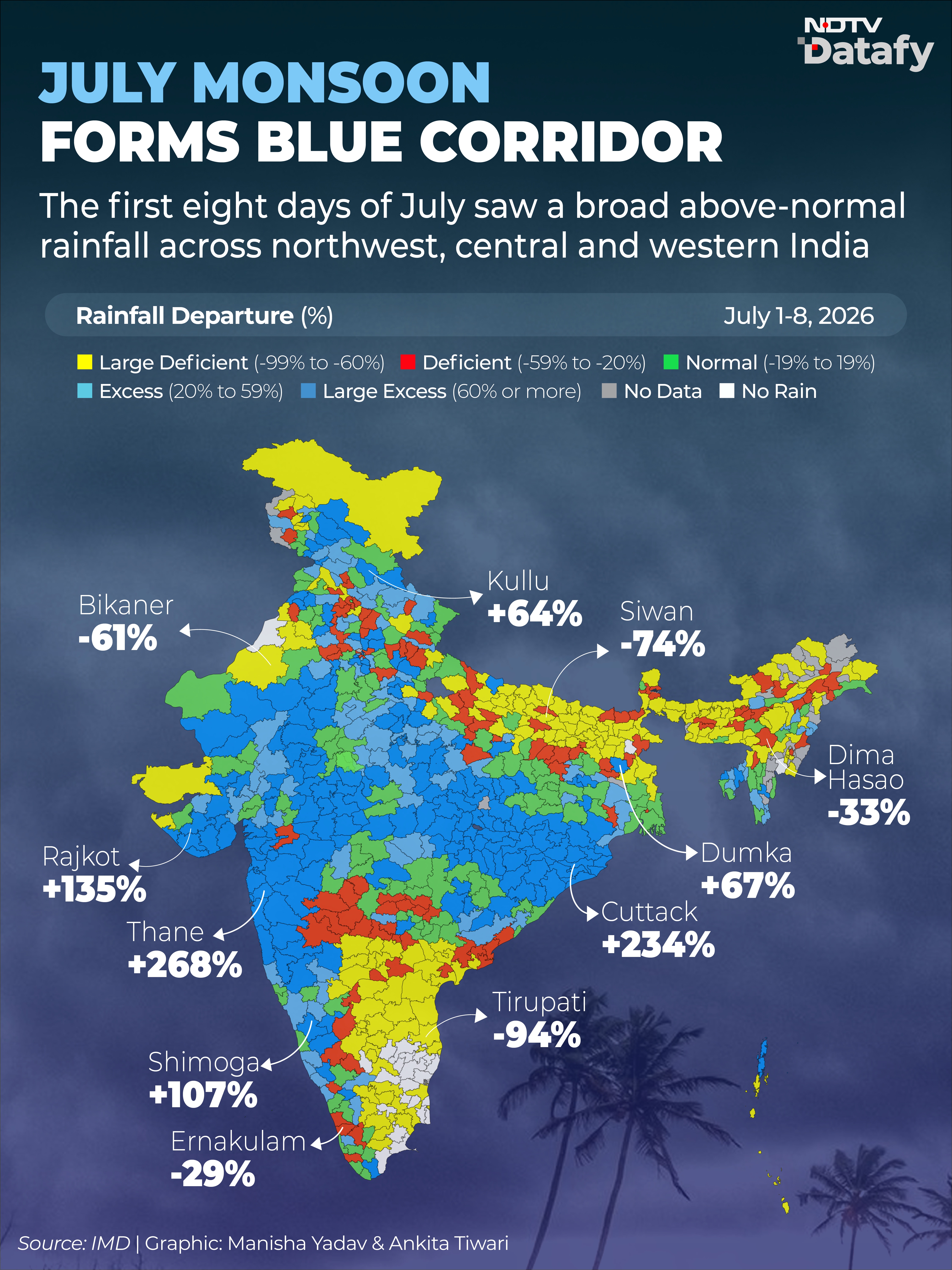
This uneven distribution is becoming visible in the disasters unfolding across the country. A few days of heavy rain have caused flooding and landslides even though many regions remain below their seasonal rainfall totals.
Kerala: Landslide In A Rainfall-Deficit District
In Kerala, five people died after a landslide in Wayanad this week. The district received heavy rain over two days, but its cumulative monsoon rainfall is still below normal.
The Weather Office data shows Wayanad has recorded a 56 per cent cumulative rainfall deficit since the start of the monsoon. Most districts in Kerala continue to remain in the deficient category, with departures ranging between 20 per cent and 59 per cent below normal.
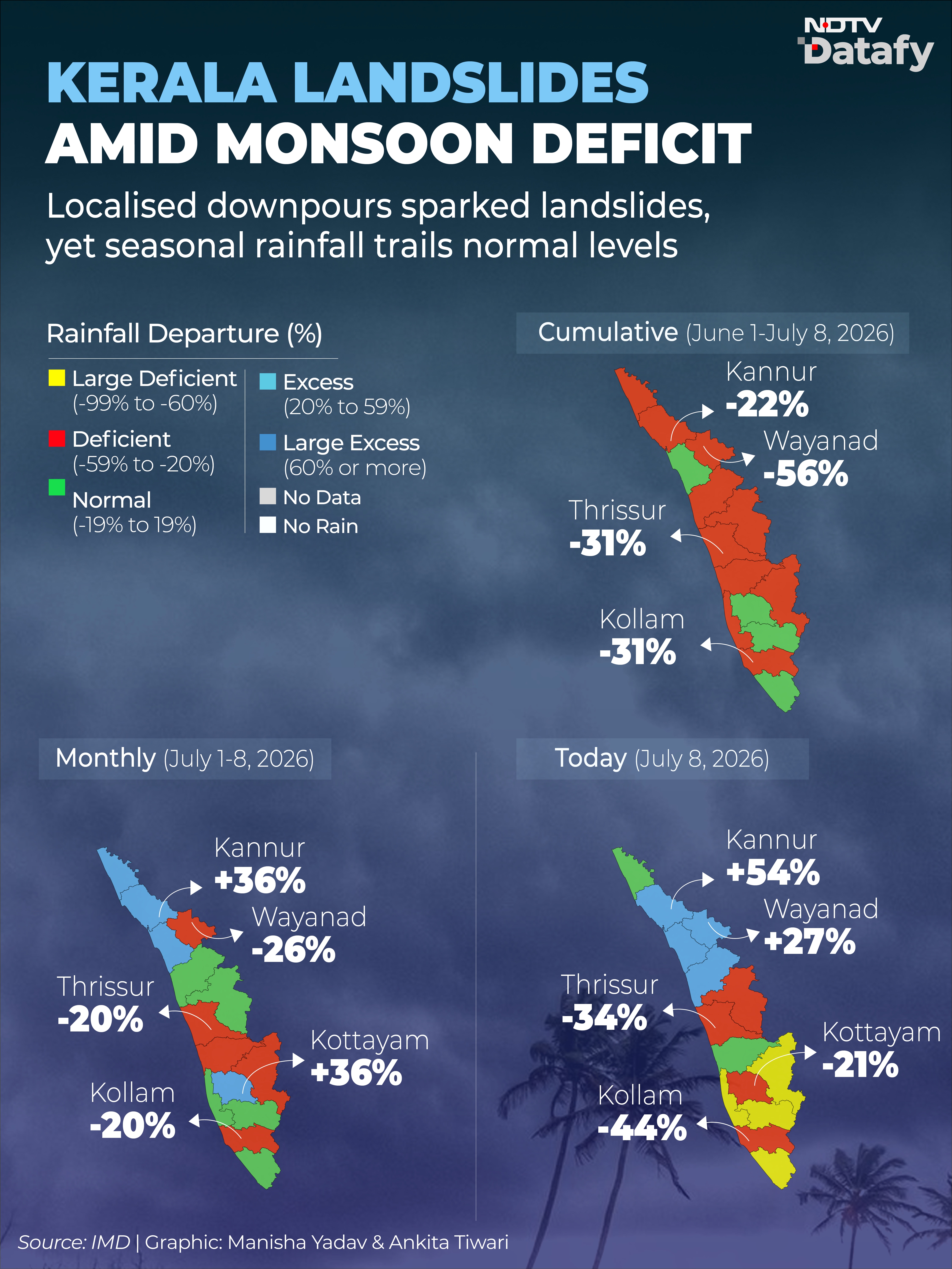
Even during July 1 to July 8, Wayanad remained 26 per cent below normal. However, rainfall was concentrated over a short period. On July 7, the district recorded rainfall that was 41 per cent above normal, followed by 27 per cent above normal on July 8.
The contrast shows how a district can remain in seasonal deficit while still receiving enough rain within a short span to trigger landslides.
Jammu And Kashmir: Cloudburst Amid A Seasonal Deficit
Jammu and Kashmir also witnessed cloudbursts this week, including one in Doda district that damaged homes, roads and other infrastructure.
According to the Weather Office, a cloudburst is rainfall of 100 mm or more within one hour over an area of about 20 to 30 square kilometres. Such intense rainfall often triggers flash floods because the ground cannot absorb water quickly enough.
Despite these incidents, the cumulative rainfall picture across Jammu and Kashmir is very different. Most districts continue to fall in the normal or deficient rainfall category.
Only a few districts have recorded large excess rainfall, including Samba (83 per cent) and Udhampur (79 per cent). Poonch, Ganderbal, Pulwama and Baramulla are also in the excess rainfall category.
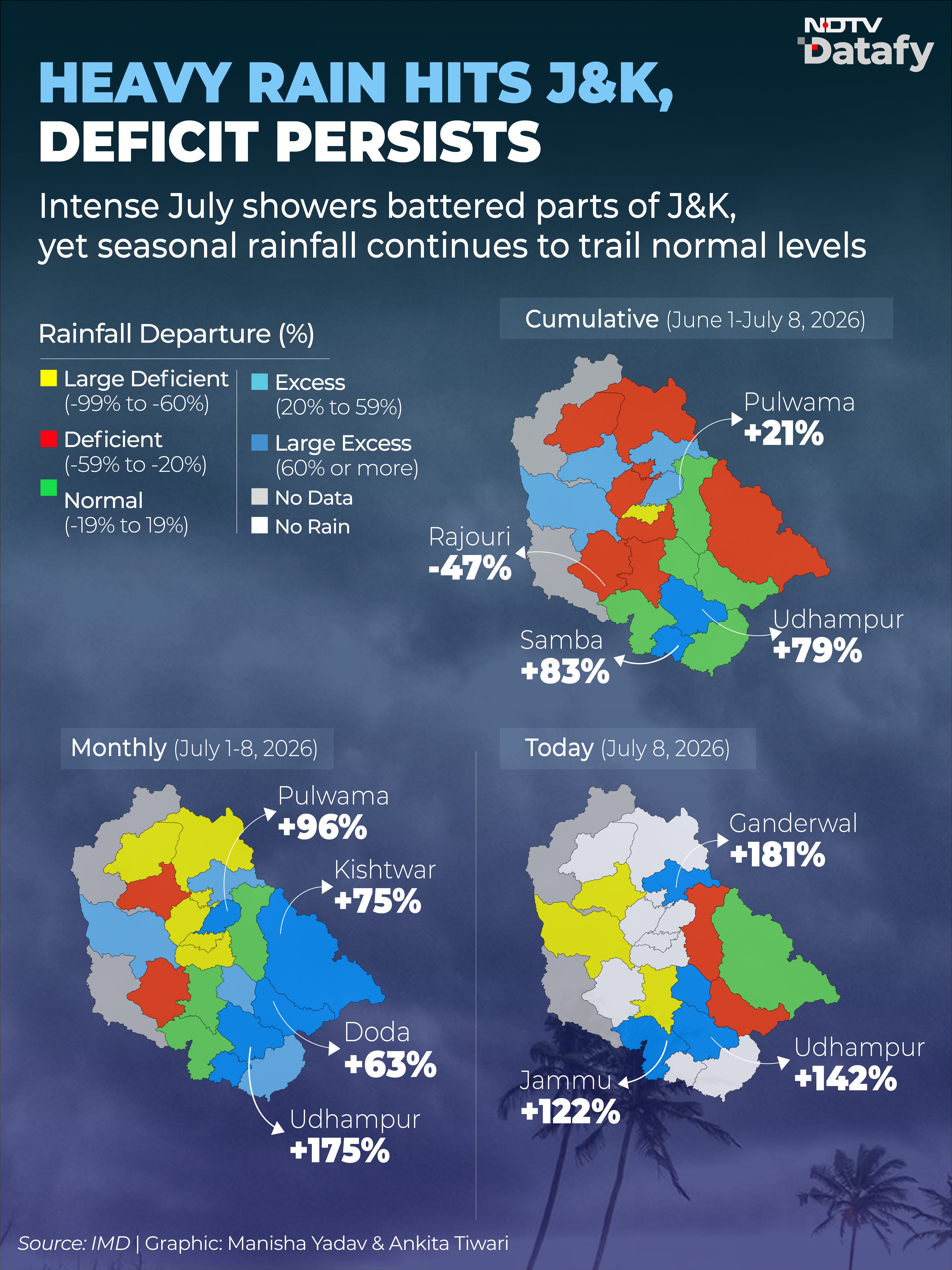
The monthly rainfall map, however, tells a different story. Between July 1 and July 8, much of the Union Territory turned blue, indicating above-normal rainfall. Districts including Pulwama, Udhampur, Samba, Doda and Kishtwar recorded large excess rainfall during the week. By July 8, rainfall had eased across most districts, with only a few continuing to receive large excess rainfall.
Heavy Rain Hits Other States Too
Maharashtra also witnessed heavy rainfall during the first week of July. Several districts reported flooding, waterlogging and landslides, while authorities issued warnings for parts of the Western Ghats. Mumbai and surrounding areas saw widespread disruption, with local transport affected in several places.
In Gurugram, a spell of heavy rain led to severe waterlogging on major roads. Traffic crawled for hours, vehicles remained stranded and normal life was disrupted once again.
India remains 15.2 per cent below normal for the season, but the monsoon has arrived in short, intense bursts rather than being spread evenly over weeks. Those bursts have been enough to trigger landslides, flood cities and damage infrastructure.
The bigger question is no longer just how much rain India receives by the end of the monsoon, but how that rainfall is distributed. If just a few days of heavy rain can cause such widespread damage while the country remains in deficit, it raises fresh concerns about the impact of more extreme rainfall events later in the season.
Source link
[ad_3]

