
Beijing13 minutes ago
- copy link
In the last week of February, even before the first missile was fired, it was revealed on Chinese social media that America was going to launch a major attack on Iran.
Satellite photos related to the preparations of the US Army started spreading on Chinese social media.
In these pictures, fighter planes standing on the runway, transport planes landing on a desert airfield and fighter jets standing on the deck of an aircraft carrier in the Mediterranean Sea were visible.
The special thing about these pictures was that a lot of information was given in them. This information was not written in English, but in Mandarin (Chinese language).
The images indicated the names of aircraft, pointed out missile defense systems and showed the presence of troops with precise locations.
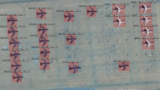
24 February: Satellite images showed military aircraft at Prince Sultan Air Force Base.
Chinese AI company had shared pictures
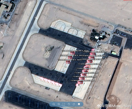
In a photo, Lockheed Martin’s F-22 stealth fighter was seen standing at Israel’s Ovda Air Base. The second photo showed the increased deployment of aircraft and support systems at Saudi Arabia’s Prince Sultan Air Base.
Apart from this, American military bases in Qatar, Jordan and Bahrain were also shown on the map. All these photos were shared online by a Chinese Artificial Intelligence company, which employs less than 200 employees.
On February 28, America and Israel together launched air strikes on Iran under the name “Operation Epic Fury”. After this, Tehran responded with missile and drone attacks.
But there was something else going on parallel to this conflict. Satellite photos continued to appear on the Internet, showing the activities of American aircraft, missile defense systems and navy. All these pictures were being shared by Shanghai-based geospatial intelligence company MizarVision.
24 February: Satellite images showed military aircraft parked on the runway of Prince Sultan Air Force Base.
What did you see in the pictures?
The first set of big photos are said to have surfaced around February 20.
Mizar Vision released a list of high-resolution satellite images that showed the deployment of US aircraft at Ovda Air Base in southern Israel, the presence of fighter jets in several Middle East countries including Saudi Arabia and Qatar, naval activities in the Arabian Sea and the movement of aircraft carriers.
Information was added to each photo with the help of Artificial Intelligence. Aircraft types were described, support aircraft were identified and missile defense systems were identified.
By March 1, this data had increased significantly. MizarVision also released new photos of military bases in Jordan, Kuwait, Bahrain and the United Arab Emirates. The types of aircraft, arrangement of air defense systems and deployment of troops were recorded in these photographs.
February 26: Satellite images showed a KC-135, two C-130 aircraft and about seven attack helicopters parked on the runway of Al-Udeid Air Base.
Shared on X with exact location
These photos were posted on social media platform X and Chinese platforms such as Weibo along with the exact location. Some of these posts were also shared by accounts associated with Chinese government media and experts associated with the People’s Liberation Army (PLA).
Many important military platforms of America were seen in these pictures. Satellite images showed F-22 stealth fighters parked at Ovada Air Base, just as the war was about to begin.
According to the photos, seven F-22 aircraft were parked near the runway and four more F-22s were seen on the runway. About 24 hours later, “Operation Epic Fury” began.
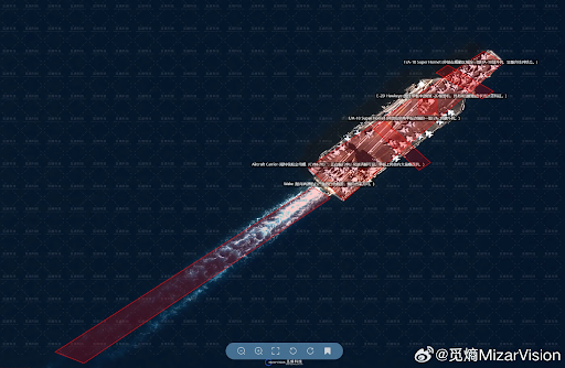
Satellite images showed the USS Ford aircraft carrier departing from the Suda Bay naval base.
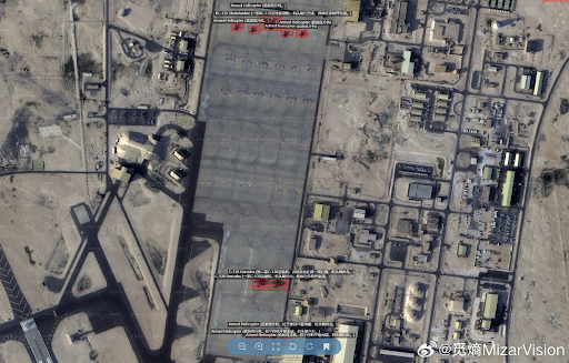
Other photos showed activity at Saudi Arabia’s Prince Sultan Air Base. Seven Boeing E-3 Airborne Warning and Control System aircraft and two Bombardier E-11 communication aircraft were said to be deployed here.
Apart from this, satellite pictures of Qatar’s Al-Udeid Air Base were also revealed. Later this base became the target of Iran’s missile and drone attacks.
The photographs were not limited to just the airfield.
Monitoring aircraft carriers from space
Naval activities at sea were also tracked.
MizarVision released satellite images showing the US Navy’s newest aircraft carrier, the USS Gerald R. Ford. The ship was seen after leaving Suda Bay naval base in Crete.
The photos showed a Boeing F/A-18E/F Super Hornet fighter and Northrop Grumman E-2D early warning aircraft on the deck of the aircraft carrier.
Another satellite image showed the USS Abraham Lincoln aircraft carrier meeting a supply ship in the Arabian Sea near Oman.
The company also combined satellite images with open-source flight tracking data.
Using aircraft tracking tools, analysts tracked a US Navy Boeing P-8A maritime surveillance aircraft taking off from Isa Air Base in Bahrain. The aircraft was headed towards the area of the Arabian Sea where the Abraham Lincoln Carrier Group was likely to be present.
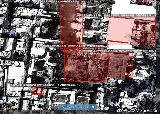
Satellite images show damage to many buildings in Iran’s capital Tehran following US and Israeli attacks.
photo publishing company
Unlike US companies like Vanator (formerly Maxar Intelligence) or Planet Labs, which run their own satellite networks, MizarVision primarily does analysis and data processing.
According to analysts, its role is like that of an “information aggregator”.
The company combines a variety of public data, such as commercial satellite images, ADS-B aircraft tracking signals and AIS ship tracking data.
All this data is processed through artificial intelligence models, which automatically identify military equipment.
The data generated in this way is similar to geospatial intelligence, which is generally prepared by national intelligence agencies.
The company has also been called the “Bloomberg of Intelligence” because it combines and analyzes data from different sources on a single platform.
Where does satellite data come from
The satellite images used by MijarVision may have come from two possible sources.
The first source may be China’s Jilin-1 satellite network, operated by Chang Guang Satellite Technology.
The Jilin-1 network consists of more than 100 Earth observation satellites. Many of these satellites take sub-meter resolution images. In such clear photographs, planes parked on the runway and different missile defense systems can be identified.
Another possible source could be Western commercial satellite companies, such as Vantours, Planet Labs and Airbus Defense and Space, which run satellite networks around the world and sell the images commercially.
Did Iran use this data?
There is no definitive evidence that Iran used these photographs to direct its attacks. But many of the military bases previously featured in MizarVision’s posts later became targets of Iranian missile and drone attacks.
These included Qatar’s Al-Udeid Air Base. Iran also targeted military targets in Jordan, including the Mowafaq Salti Air Base. Here the AN/TPY-2 radar system worth about $300 million, used for the American THAAD missile defense system, was destroyed.
Later satellite images also confirmed the destruction of this radar system. This system was considered very important for missile defense in the Gulf region.
After the destruction of the radar, the responsibility of stopping the missile largely fell on the Patriot missile batteries. But the PAC-3 interceptors used in these are already available in limited numbers.

Source link
[ad_3]

